Carto Lab
  • [email protected]
  • Home
  • Research
  • Projects
  • Publications
  • People
  • Alumni
  • Equipment
  • Contact
  • Home
  • Research
  • Projects
  • Publications
  • People
  • Alumni
  • Equipment
  • Contact
3D Mapping

3D Mapping after earthquake

caa20182024-03-03T14:09:02+02:00

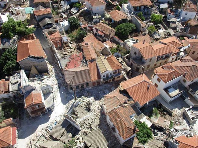
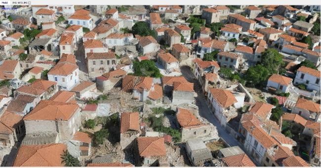
3D Mapping of the Vrissa region affected by the earthquake of Lesvos on 12/06/2017

Following the devastating earthquake of June 12, 2017, and the extraordinary conditions prevailing on the island of Lesvos the work of 3D mapping has been initiated in the affected area of the village of Vrissa. The project is being carried out by a specialized interdisciplinary research team from the University of the Aegean with the use of the appropriate technical equipment.

Fully reliable and high spatial resolution data (less than 1 cm) in three dimensions are provided from the implementation of high-resolution mapping techniques such as state-of-the-art technologies of aerial and terrestrial photogrammetry, UAV-Drones, Laser Scanners and cameras. Collected data is being utilized for 3D modeling of buildings by specialists studying the seismic behavior of the building stock and damage assessment.

3D Mapping

Preliminary results from the three-dimensional mapping process are provided on the following websites of the Research Laboratories of Cartography and Geoinformatics of the Department of Geography and from the Environmental Quality and Geospatial Applications of the Department of Marine Sciences

https://youtu.be/hSjPIRw9jFM

https://youtu.be/_owUV3myaeU


Related Posts

2023-2026: ARGUS Project

ARGUS: Non-destructive, scalable, smart monitoring of remote cultural treasures

Department of Civil Engineering and Geoinformatics of Cyprus University of Technology (HORIZON-CL2-2023-HERITAGE-01,... read more

LC3 Project

2023-2025: LC3 Project

LC3: Lemesos City Cooling Challenge

Department of Civil Engineering and Geoinformatics of Cyprus University of Technology (NetZeroCities Pilot Cities Programme, NZC-H2020-202209,€1,500,000). ... read more

Seagrass

Seagrass mapping in Greek territorial waters using Landat-8 satellite images

Seagrass meadows are among the most valuable coastal ecosystems on earth due to their structural and functional roles in the... read more

Recent Posts

2024-2025: DEPLOYED Project
2024-2027: ORIENTATE Project
2024-2027: COASTLINE Project
2024-2026: CONNECTING Project
2023-2026: ARGUS Project
LC3 Project
2023-2025: LC3 Project
2022-2024 Oenowatch Project
High Precision Survey of Ports
© Copyright 2023. All Rights Reserved.