Marine Litter Detection
Preliminary study on the emerging marine litter problem along the eastern coast of Lesbos
The objectives of this preliminary study were to assess: (i) the extent of the refugee arrival related marine litter problem along the eastern coast of Lesbos; and (ii) the efficiency and cost-effectiveness of new technologies to provide quick, accurate and quantitative assessments of the marine litter distribution in order to plan efficiently the cleanup operations.
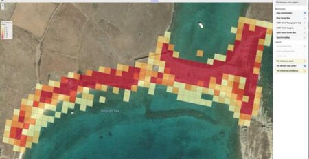
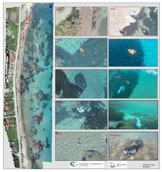
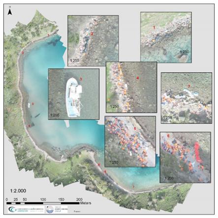
The study has shown that the eastern coast of Lesbos faces a very significant environmental problem which may very soon spiral out of control. Wide stretches of the coastline are overwhelmed by marine litter, such as shipwrecks and PVC boat remains, lifejackets, discarded clothing and personal items, boat engines and engine fragments. It was also found that litter concentrations varied along the coastline in terms of their distribution over the ‘dry” (land) beach and the nearshore seabed. In some areas, there was extensive littering of the dry beach but not of the nearshore seabed, whereas other areas, both with good and very poor (or no) access, showed small quantities of litter on the dry beach but extensive littering on the nearshore seabed. The nearshore seabed offshore of cliff coasts which due to complete lack of access have been not used as entrance points were found to be full of diverse litter as observed by dedicated dives; this may be due to hydrodynamically dispersed litter from neighboring areas.
UAV surveying proved to be a very accurate, efficient and low-cost method to obtain the geospatial information needed for quantifying the litter problem along the coast that is a prerequisite for the efficient planning/implementation of remediation responses.
Publications
- Doykari M., Papakonstantinou A. , Topouzelis K, ” The use of UAVs for mapping immigrant sea litter: the case of Lesvos island”, 14th Conference of the Greek Cartographic Society, ,2-4 November, Thessaloniki ,2016. (in Greek)
- Velegrakis A., Andreadis O., Papakonstantinou A.,Manoutsoglou E., Doukari M., Hasiotis T., Topouzelis K. and Katsanevakis S., 2016, “Preliminary study on the emerging marine litter problem along the eastern coast of Lesvos isl., Greece”, 41th CIESM Congress, Kiel, Germany, 12-16 September.
- A.F. Velegrakis, O. Andreadis, A. Papakonstantinou, K. Topouzelis, S. Katsanevakis, E. Manoutsoglou, M. Doukari, F. Psarros , P. Doukari Michaela and Th. Hasiotis, “Preliminary study on the emerging marine litter problem along the eastern coast of Lesvos“, April 2016, White paper for Municipality of Lesvos.