Participation in AMOS project
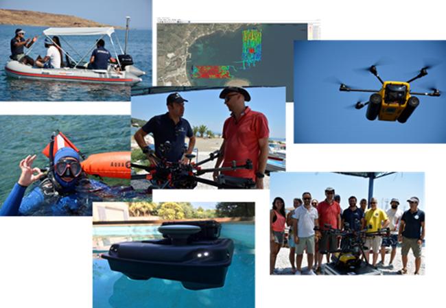
Geospatial Enabling Technologies (GET) in cooperation with the French SME SEMANTIC TS successfully completed between 5 and 10 of July in Lesvos island the pilot of the AMOS project “Shallow Water Aquatic Monitoring using Acoustic Sensors and Satellite Images” which is funded by the European Union’s NEPTUNE Horizon 2020 project.
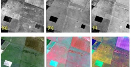
The aim of the AMOS project is to develop an innovative system for monitoring the marine ecosystem using acoustic methods and satellite data. Within the project, SEMANTIC TS developed an autonomous single beam system capable of monitoring, even in difficult accessible shallow waters, with great accuracy the depth of the sea and the seabed type, including the existence of Posidonia meadows that are particularly important in the sensitive marine environment. At the same time, GET is developing a web application that exploits and visualize all the free environmental data of Copernicus, providing access to satellite data from Sentinel, as well as on thematic products such as chlorophyll concentration, sea temperature, water color and more.
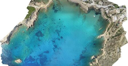
During the pilot in Mytilene, the equipment developed under the project was tested in real life conditions, at the beach of Pamfila and in the Gulf of Kalloni.
The project was supported by the Department of Marine Sciences of the University of the Aegean and in particular the Marine Remote Sensing Group (MRSG) (https://mrsg.aegean.gr/). The MRSG provided the necessary equipment to carry out the pilot and also UAVs, to create high-resolution ortho-photo maps of the study areas, as well as divers to collect underwater photographs to be used as ground truth of the collected data.
Geospatial Enabling Technologies is an innovative Greek company active in the fields of GeoICT, Enviromatics, Open Data and geospatial business intelligence. The company, located in Athens, implements projects using free / open source software, such as GET SDI PORTAL which was entirely developed by the company, open standards and remote sensing satellite data (http://www.getopendata.gr).
SEMANTIC TS is a French company specialized in the provision of oceanographic and acoustic services for monitoring of the marine environment. The company has developed and installed software for the French Navy ships, as well as innovative acoustic monitoring systems used in AMOS project.
NEPTUNE PROJECT has received funding by the European Union’s Horizon 2020 Program under Grant Agreement 691554