3D Mapping

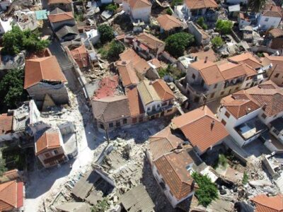
3D Mapping after earthquake

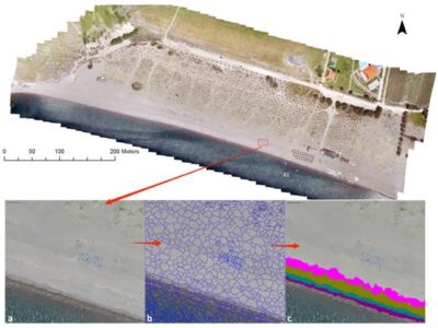
3D Mapping of the Vrissa region affected by the earthquake of Lesvos on 12/06/2017 Following the devastating earthquake of June 12, 2017, and the extraordinary conditions prevailing on the island of Lesvos the work of 3D mapping has been initiated in the affected area of the village of Vrissa. The project is being carried out by a specialized interdisciplinary research team from the University of the Aegean with the use of the appropriate technical equipment. (more…)
AMOS project

Participation in AMOS project

Geospatial Enabling Technologies (GET) in cooperation with the French SME SEMANTIC TS successfully completed between 5 and 10 of July in Lesvos island the pilot of the AMOS project "Shallow Water Aquatic Monitoring using Acoustic Sensors and Satellite Images" which is funded by the European Union’s NEPTUNE Horizon 2020 project. (more…)
SPOTS Experiment

SPOTS Experiment

Summary

The SPOTS project will take a closer look at the influence of biofouling and water depth on the spectral reflectance of plastics. By varying the water depth and degree of biofouling systematically and in a controlled lab and outdoor environment, we will gather a more detailed dataset and predictive model about the influence of both these factors on the hyperspectral footprint of plastic litter. Besides debris from the marine environment, we will also investigate coastal and riverine plastic litter. (more…)
COASTAL Mapping-1

COASTAL Mapping in Lesvos Island

Researchers have developed specific methodologies for identifying coastline and coastal zones (coastal morphology). The availability of very high-resolution digital surface models (DSMs) and orthophoto maps is of increasing interest to all scientists, especially those monitoring small variations in the earth’s surface, such as coastline morphology. (more…)
Seagrass mapping

Seagrass mapping

The Common Fisheries Policy of EU requires mapping highly important habitats for fish production (e.g. underwater flowering meadows) in all EU Member States for the sustainable management of living aquatic resources and marine ecosystems. The Mediterranean region is under Regulation (1967/2006), and the fishing activities must be based on specific plans according to fishing zones which require knowledge on the distribution of underwater vegetation. In particular, the regions covered by marine angiosperm plants such as the endemic species of Mediterranean Posidonia oceanica (Posidonia), are areas of great ecological and economic interest for which mapping at the country level required a cost-effective and highly accurate methodologies. (more…)
Marine Litter Detection

Marine Litter Detection

Preliminary study on the emerging marine litter problem along the eastern coast of Lesbos

The objectives of this preliminary study were to assess: (i) the extent of the refugee arrival related marine litter problem along the eastern coast of Lesbos; and (ii) the efficiency and cost-effectiveness of new technologies to provide quick, accurate and quantitative assessments of the marine litter distribution in order to plan efficiently the cleanup operations. (more…)